Tucker County West Virginia
RM1329.7/T1108 Leadmine WVa–left CR7 South–red headed woodpecker, deer(9).
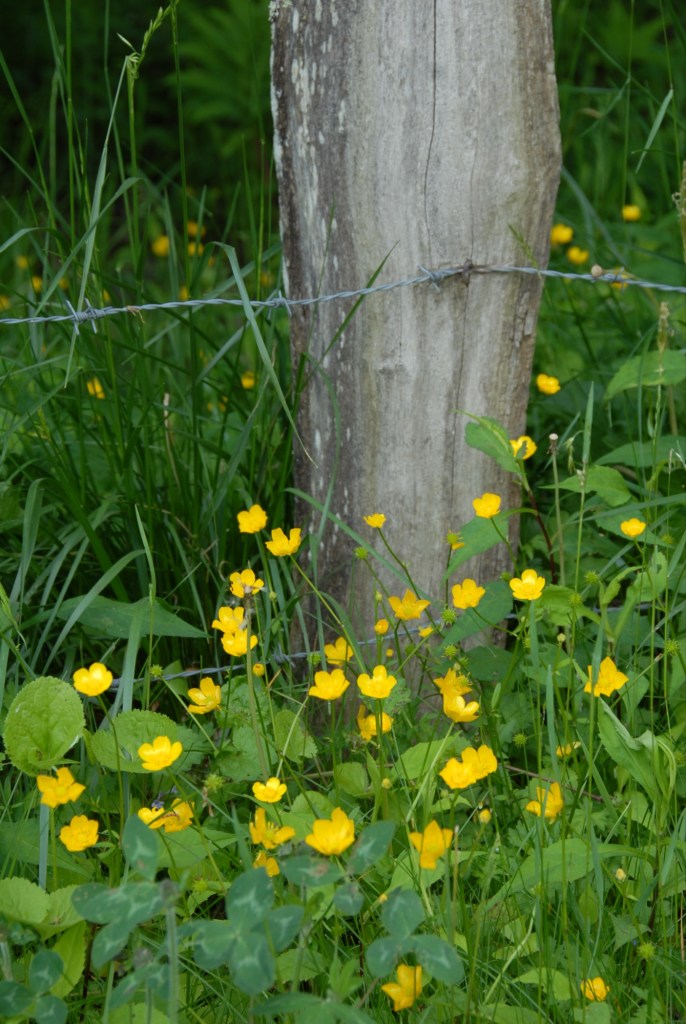
RM 1330.3/T1124 Buttercups
Tucker County West Virginia
RM1329.7/T1108 Leadmine WVa–left CR7 South–red headed woodpecker, deer(9).
RM 1330.3/T1124 Buttercups

Lumpkin County Georgia
RM72.7 T0953 Stop @ Hardees. Cold, Cold, Cold.
Dep 1016
RM73.2 T1019 Stop in Dahlonega Square
Side note: TOTAL MILES ON BEAGLE
100,034.7 over 100,000
RM76.0 T1102 Left on CR187 Wahsega Rd toward Camp Frank D. Merrill
RM81.9 T1113 Left on CR166 Berry Miles Road.
RM88.3 T1123 Arrive JCT CR72 Hightower Church Rd @ Etowah Headwaters Crossing.
DEP 1129. The Cream Colored Carolina Vetch is out. Tosses freshly in the wind. Shivering as if from the cold.
Robbins Plantain resists stiffly.
Right on CR72
RM83.9 T1137 Stop for Crested Iris

0945 RM(road mile) 75.1 Lake Rock Eagle, Putnam County Oconee National Forest
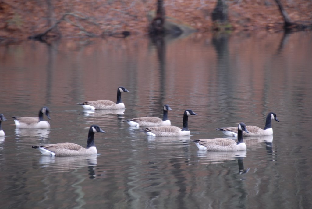
A sizeable flight of Canadian Geese arrived at the SW Gate. Landed smack dab in the middle of the Lake. No fools them water Geese. I counted about 5 dozen. Heads erect, necks long and straight. Black, from the tip of top down their necks to the shoulder near the water line. Maybe 100 yards away. Not the same few who honked last night. They’re still across the water near the 4-H Camp Complex. Honking occasionally. These new arrivals announced themselves well in advance. A foretaste. I heard this uproar, a clamorous honking, and thought the 4-H geese had stepped on a snake or some thing. But the clamour rose, volume increased, signaling a major happening about to happen. “They must be in the water, across the Lake by the far shore, ” I thought to myself naively. As I strolled down slope to the water’s edge, for a better look.(Now I wish I had brought my binoculars. “Naw, I won’t need them,” says me, to myself, yesterday.)
I looked across the water and could not see any floating geese, certainly not enough to sponsor the swelling racket. Closer, louder, and more rancorous with each step I took. “Maybe they’re scrunched down in the marsh fringe.” “Smart beggars to hide like that, while raisin’ such a fuss.” I love the call of Canada Geese. A honking that I cannot describe, but know to hear. If I could be re in carnate I would choose to return as a Canada Goose. To be able to make that wonderful forlorn sound. That sound that triggers in me a sense of wilderness and splendid isolation. A sound that seems to echo madly even when there are no available surfaces to return an echo. Then when 60 geese honk and echo excitedly, mixing together their bleating calls, the result reminds me of a giant marquee filled with small bulbs. Each blinking randomly. A reverberating twitter, hypnotic…Well, to make a long story short, do you know how big a 747 is? If you stand in front of one, looked at it from about a 30 degree angle to the left of it’s center line, do you recall how big a 747 would look, The entire span, from its right wing tip on your left, foward to its nose, then receding to its left wingtip on your right. Do you sense how big that wedge would look from wing tip, forward to nose, then back to wing tip. I’m talking your basic big. Well, as I drew closer to the Lake fringe on my side, searching for the sneaky geese hiding in the marsh fringe on the other side, the loud flittering rancor growing more rancorous, almost hurting, this huge humongous 747 rose majestically from behind the horizon and aimed itself directly at me. The wonderful fuss was, of course, not a band of sneaky geese surreptitiously skulking in the fringe. But, a mighty flight approaching Lake Rock Eagle from the SW. Chattering amongst themselves. Escalating their messages as they approached the landing. Coordinating their landing instructions. Forming a smoother wedge for turbulence reduction. Looking for trouble. Assessing landing possibilities. Lookouts posted. Strong members to the outside. Weaker to the inside. Polling each other for important data. Fixing on The flight leader at the point of the wedge. Sensing wind. Adjusting altitudes, of each member, and of the entire Vee. Rising to clear a patch of trees then sloping gradually, down the invisible incline. Wings moving them forward, Wings slowing. Still slowing. Down the incline. Toward the geometric center of the lake. Effortlessly, unerringly. In perfect formation. In wonderful harmony. Unison. Gliding the last 50 yards. Easing downward. Wings braking. Heads up. Tails down. Chests out. Feet extended. Then, puff. I really mean “puff”, 60 Canadian geese touched down with a collective “puff.” Each gliding forward several feet to dissolve his momentum into the water surface. Sixty small wakes. A huge cheer. High fives all around, like a championship locker room. Congratulations and exhilarations. A mighty celebration. Flapping, preening, stretching, coasting into a tight huddle. I want to be a Canada Goose.
Note addendum on adjoining journal log page: Spellbound. Fifty yards across, for sure. Appearing suddenly, Monstrous. Covered the entire expanse of Lake across from me. My eyes pop. My jaw drops. My knees knock. I feel naive and stupid for looking at the marsh fringe. I feel priviledge and wonder-struck. The total surprise, far beyond any humble expectations.
RM 75.1 T 1140 Depart Lake Rock Eagle. Warm, pleasant, slight breeze. Hazy. Go back the way I came in. Look for rest rooms. CR2 NW
Arise 0900 RM(road mile) 118.6 Union County GA
WOODTHRUSH. Even tho’ this camping setup is dominated by trout fishermen(Cooper Creek, too), and even tho’ fishing and hunting campsites usually get all beat up and trashed up, my site still grows a number of nice flowers. Especially Rose Trillium. Abundant moisture really brings out the flowers. Even in well-worn spots. Arranged and re-packed the truck. My rhythms need revitalizing, and parts of my gear, too. Batteries run down. Items missing. Odds-and-ends pulled out of my total “road kit” during the house move. Oil can. For several months I have suffered tears and heartbreak at an ever-intensifying rattle and clatter in the Beagle’s back tailgate and/or flip windows. Hopefully, this morning I have found the problem. The main lynch pins in the two hinges in the tail gate had worked their way loose. The left one had slipped about 3/4″ to the right(out of its socket). The left had worked, maybe, 2 1/2″ left out of its ratched, and completely out of its right hand anchor. With my hatchet, a hammer and channel locks, as driver, I knocked them back into place. A drop-or-two of oil would’ve helped. Let’s hope that my back door rattle blues will now abate for a while.
RM118.6 T1029 Engine on. Gear stowed.
RM118.6 T1033 Head back North, the way I came last night, on FS4/CR228. That’s Mulky Road and Mulky Gap from old Lotus Blossom Days. This time, however, branch east from Mulky Road onto FS39/CR109. Thence up to the crest of Duncan Ridge–headwaters of the Tennessee and —-. East back to Sosebee.
RM118.6 T036 Depart FS4
RM119.3 T1041 Stream side campsite.
RM119.6 T1044 Arrive FS39/CR109 at Mill Shoals Creek. There’s a creek side pulloff @ Mill Shoals Creek.
RM121.4 T1106 Arrive Crest. Could be Shape Gap. Yes. Creekside camping @ Shape Gap at Pretty Branch.
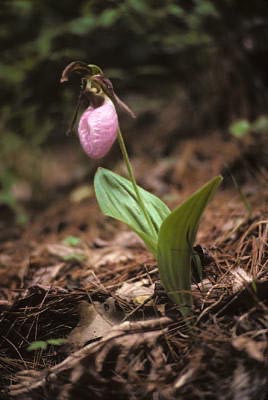
RM121,6 T1112. Found Wildflower NO. 400
Pink Lady’s Slipper. Wildflower Walk. Crested Iris, Bellwort
RM121.6 T1257 Depart

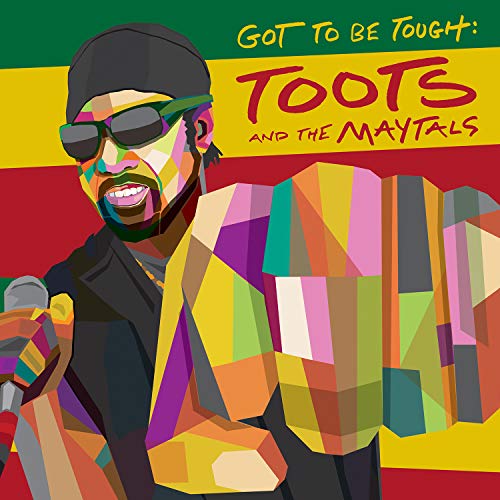
There could not be a mountain back roads run with Doctor Flowers without a fair amount of Toots And The Maytals to play as part of the soundtrack along the way. Frederick Nathaniel Toots Hibbert was a ska and reggae originator that both of us preferred to Bob Marley at the head of our Reggae Pantheon. Doc had most records Toots had released, and several more that were probably released without Toots’ permission, culled from record stores and thrift-shops. Collecting music was hard work in those days, pre-internet. Toots Hibbert enjoyed a long and durable career as singer, songwriter, and force of nature. We played his music at Doc’s Memorial Service. Toots released his final record, Got To Be Tough on August 28, 2020. He died of COVID-19 on September 11. The unspeakable tragedy of his loss is made sharper by the fact that Got To Be Tough kicks ass and is as relevant musically and lyrically as anything he put out, in over a nearly 60 years of recording. However you might listen to music, go search for it and play it all the way through. It will be better time spent than watching the news or liking a funny meme. I listen to it and think of better times for all of us. I know Doc would’ve loved it, and we would’ve mourned Toots’ passing together, either at Ground Zero with a UT Women’s game silently playing out on the TV in the background or riding slowly along some county road in North Georgia, winding through the early morning gloaming, Doc beating rhythm on the steering wheel of the ‘Ho, saying “damn, Toots”. Time is growing short for us all. I just wish Doc and Toots had gotten a little more of it. Doesn’t seem like much to ask, looking back.
 I had to burn some leave time so at the end of June I fled home and hearth and my pandemic routine for a long swing through South Georgia, looking to capture a Roy Burke back roads trip vibration to sooth my soul and slow my velocity. We lost Doc five years ago this month. The timing seemed appropriate. I traveled some 900 miles in three days, from the Kolomoki Indian Mounds outside of Blakely in Early County in the Southwest corner of the state, to the eastern and western approaches to the Okefenokee Swamp. I looped through flat Georgia farmlands and stopped for roadside pecan candies and watermelon and peaches. I beheld the Legendary Folkston Funnel and I paid my respects at Jackie Robinson’s Birthplace, on an obscure vine-tangled ridge-line at the edge of Grady County, near the Florida border. I picked the backroads as best I could, and tried to make time to document the journey with my trusty crappy Android phone camera. I brought along Doc’s old county maps to log, but also updated my navigation techniques using Google Maps and PolarSteps.
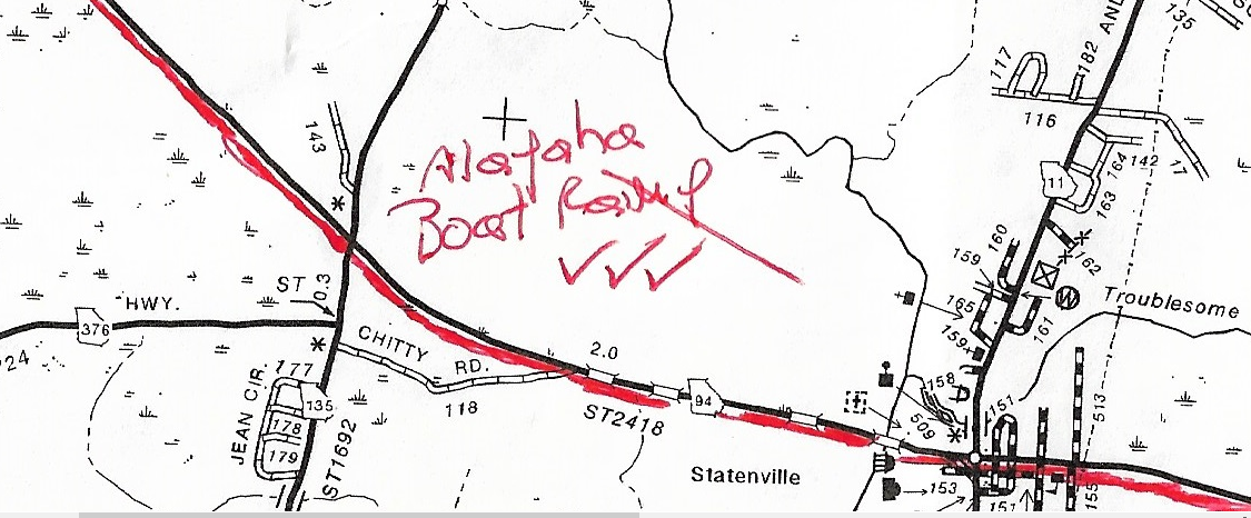
Over the course of three days there were a few moments that I was able to commune deeply with his spirit. In particular the beginning of day two, early morning out of Valdosta, fortified by Daylight Donuts, I headed across what I had figured beforehand was the crux of the run, State Route 94. It runs from Valdosta to St. George, across the most remote section of Georgia, briefly becoming Florida State Route 2. As I approached the crossroads village of Statenville in Echols County, I spied a public boat ramp at the Alapaha River crossing. 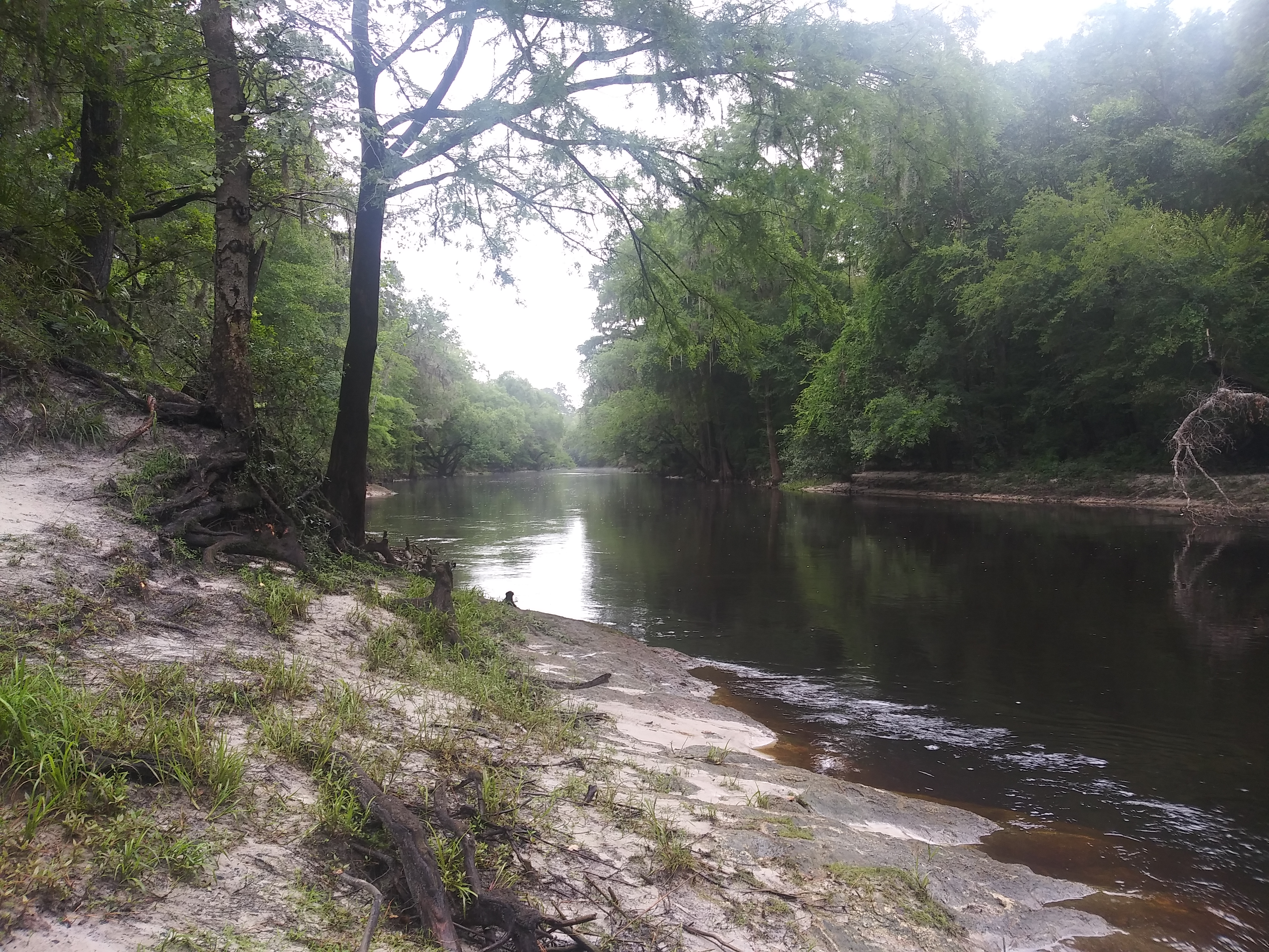
I stopped to take a few photos of the meandering, iced-tea colored water, soaking up an eco-system far removed from the urban generica monoculture I had come to shake off of my frontal lobe. It wasn’t Doc and his truck this time, just me and Scarlett the Honda. But he was close by, snickering at my pitifully limited camera. The Alapaha runs some 200 miles through South Georgia and Northern Florida, where it eventually flows into the Suwanee, then into the Gulf of Mexico. Doc would have approved of it’s calm dark slide through this mostly unspoiled place. It was my moment of Doctor Flowers satori.
Later that day in Folkston, on the other side of the Okefenokee, I took a picture of a window-door hybrid.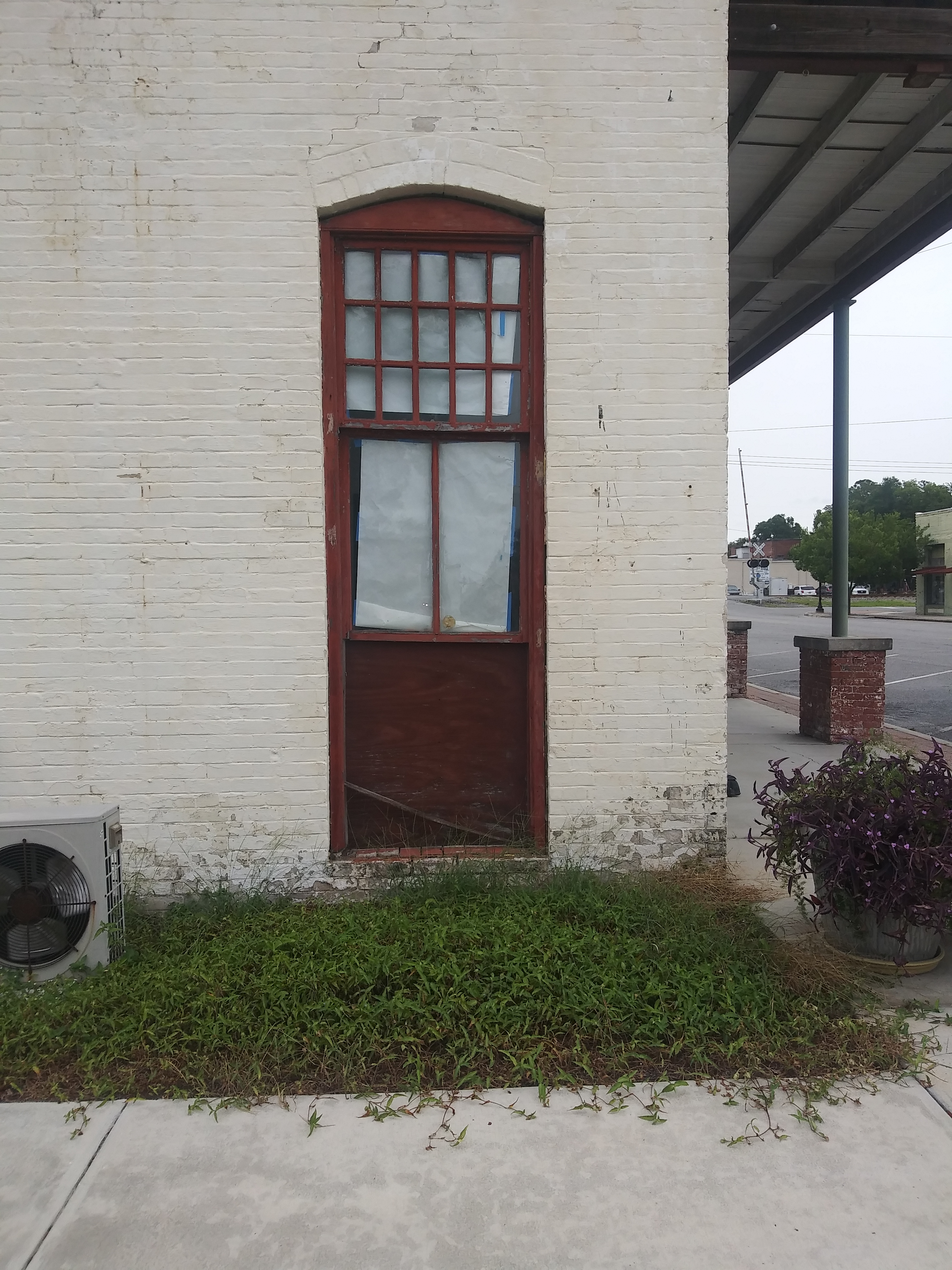
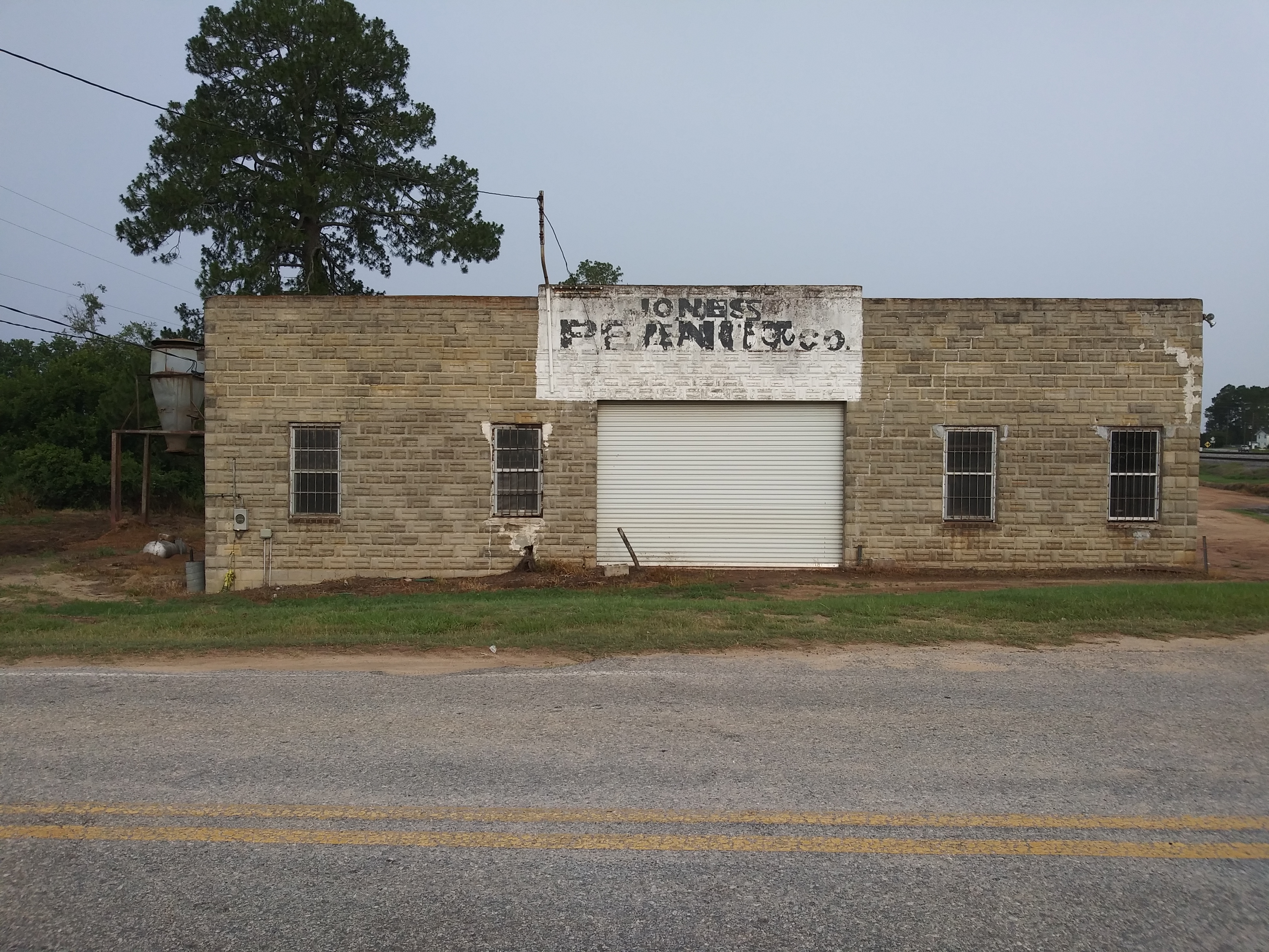
On the morning of day three, taking a county road in Tift County, I came upon the crossroads of Chula, Georgia. I actually had some good light. Doc would’ve enjoyed Jones Peanut Co.
For those of us who shared in his world until June 2015 it’s been a hole in our lives where our cup of smartness and nature and water and science and music and photography and back-road trips and quintessential curmudgeonliness used to be filled to the brim. I have intermittently tried to summon him up through his work here at doctorflowersredux. Harold and I have made several road trips in homage to Doc, tracing his maps with our memories. There have been some moments where we summoned up the right Doc Vibe, but many others where we realized that you can’t ford the same mountain creek twice, that our map skills and memories and time marching on and another new fucking Dollar Store at the country crossroads makes it hard to grasp, those moments with Doc on the road, the truck stopped as he grabbed his trusty camera for a couple of shots and wry commentary. So this was my new way to summon him up, June 2020.
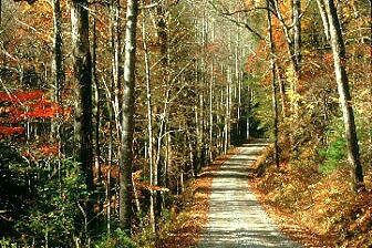
Forest Service Road 58 alongside Noontootla Creek, Rich Mountain Wildlife Management Area, Fannin County GA. Photo by Roy Burke
I was probably 24-25 years old when Doctor Flowers first showed me Noontootla Creek. It’s been my favorite place in nature within(relatively) easy reach ever since. It rolls down between mountains in and out of rocky, wild rhododendron-shaded grottos before it empties into one of those perfect little Appalachian Mountain Valleys that dot North Georgia in out of the way places down county roads to which Doc was drawn over and over again. The first time he took me there it was a full scale expedition in his recently acquired proto-SUV The Beagle, loaded to the walls with every manner of supplies and repast. Checklist that included gumboots, comprehensive photo gear, chips ahoy, vast and curated music selections via his cassette tape library, maps, rain-gear, sliced turkey sandwiches with cheese and mayo on buns, maybe sometimes a little green leafy material and accoutrements for maximum mind expansion, mixed nuts. It was a perfect crystal blue Spring day in the mid 1980s in my memory, pollen washed out of the hills by a day’s mountain rain before, listening to everything from Hearts of Space to Toots and The Maytals on the slow, deliberate ride into the mountains. When he reached the right spot along Forest Service Road 58 and hove to in the Beagle, I followed him up FS58 on foot as he walked along the road reading the flora along the road-bank aloud as sure as I would read the sports page. He identified the early Spring wildflowers one by one. Doc knew nearly all of their names and nicknames, stopping occasionally to go to the guidebook or check off one new to his current year’s list(to later be compared to a second, lifetime, master list). We went there many times over the years, during every season. We scattered some of his ashes there in a driving, crying rainstorm at Three Forks in 2016 to mark his passing. Oddly enough Doc didn’t save many photographs of the creek itself in his archives, so I present here a pic of the road along which we walked that first time, as well as another one of a violet in flower, close by the creek.
Over the years I accompanied Doctor Flowers to Noontootla Creek maybe 8-10 times. I’ve also taken friends and family there in the decades since to splash in the creek, hike, eat, drink and love. Every now and then I’ll just take off on a Tuesday and head for the hills, well past Ellijay and into the watershed of the Mighty Toccoa, winding the roads until they turn to gravel then winding them some more, until I come to that same spot along the Noontootla Creek. I’ll just stay a while, forest bathing, glad to be at my special place. But I’m always reminded of my friend who found found the Noontootla first and showed it to me. Thanks Doc.
Round Leaved Violet along Noontootla Creek. Photo by Roy Burke
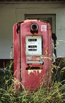
Gas Pump, Hancock County GA 1998/Photo by Roy Burke
Doc had a soft spot for abandoned, rural gas pumps. We discussed the logistics of acquiring one and putting in the back yard at Ground Zero but things never quite lined up. He took many pictures of them, though, including this one in Hancock County, Georgia in 1998.
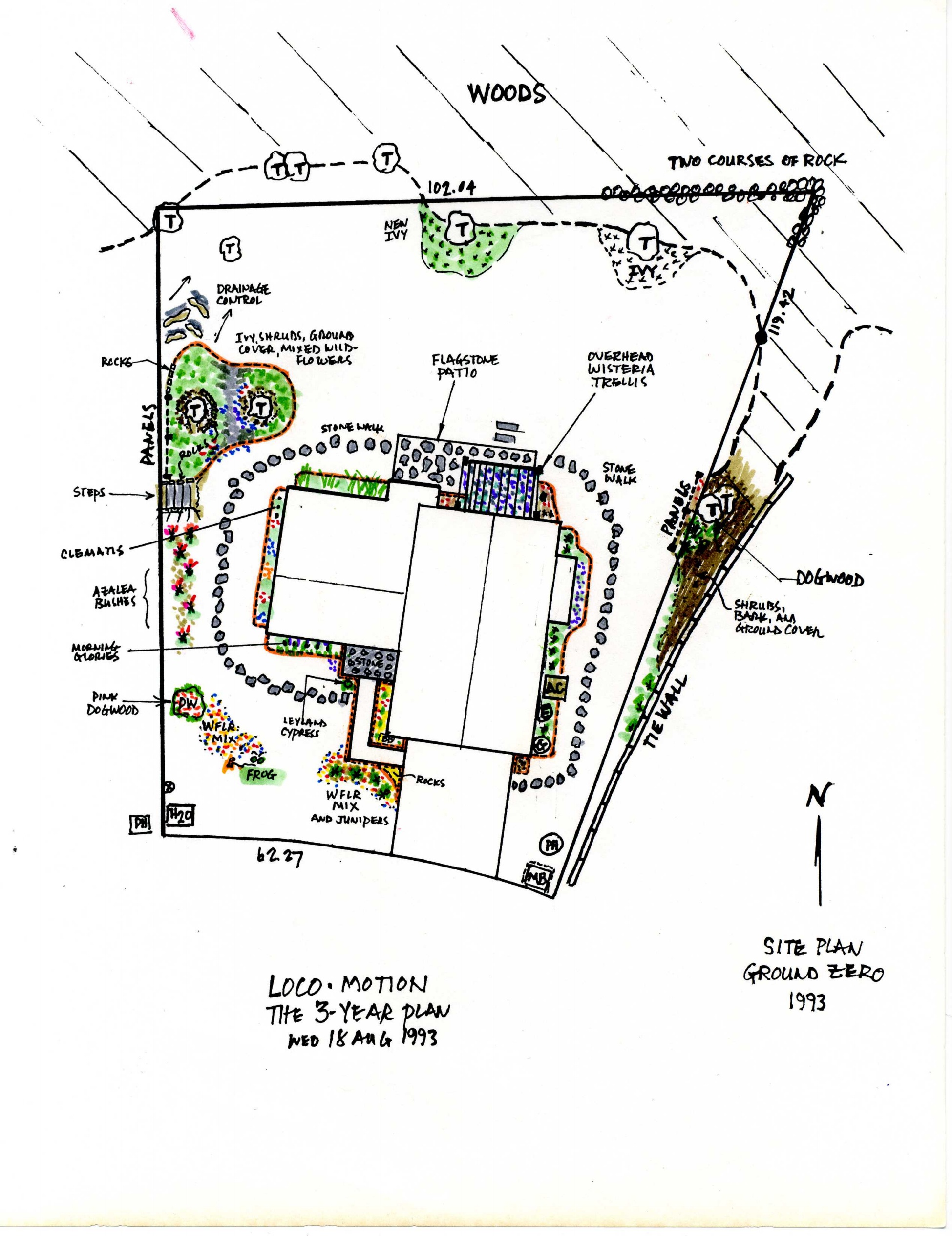 Ground Zero was Doc’s home base, his safe place, his patch of land, suburban retreat. He bought the house on Brasac Drive in Stone Mountain in the late 1980s when the neighborhood was still under construction, choosing the house and lot because it overlooked the wetlands on the fringe of Hairston Park. He could look out the back of the house and see woods and swamp, not other suburban houses. After he moved in he made a grand landscaping plan(seen above) called Loco-Motion/The Three Year Plan. Thanks to Paul Lamarre for unearthing this drawing to be seen here. Much of the plan Doc created, sweating away countless hours weeding and digging on days off, the physical labor an antidote to too many days sitting at a desk or in a conference room. He built a morning glory net over the living room picture window and enlisted some friends to pour a concrete(not flagstone) patio out back. It was his shelter and the place where he spent many of his happiest years. I and his closest friends and neighbors were lucky to spend time there with him, too. The house is still there, but Ground Zero only exists as an idea anymore, in drawings like this one, the busy, deep mind of Roy Burke spilling out on the page again, a marvel.
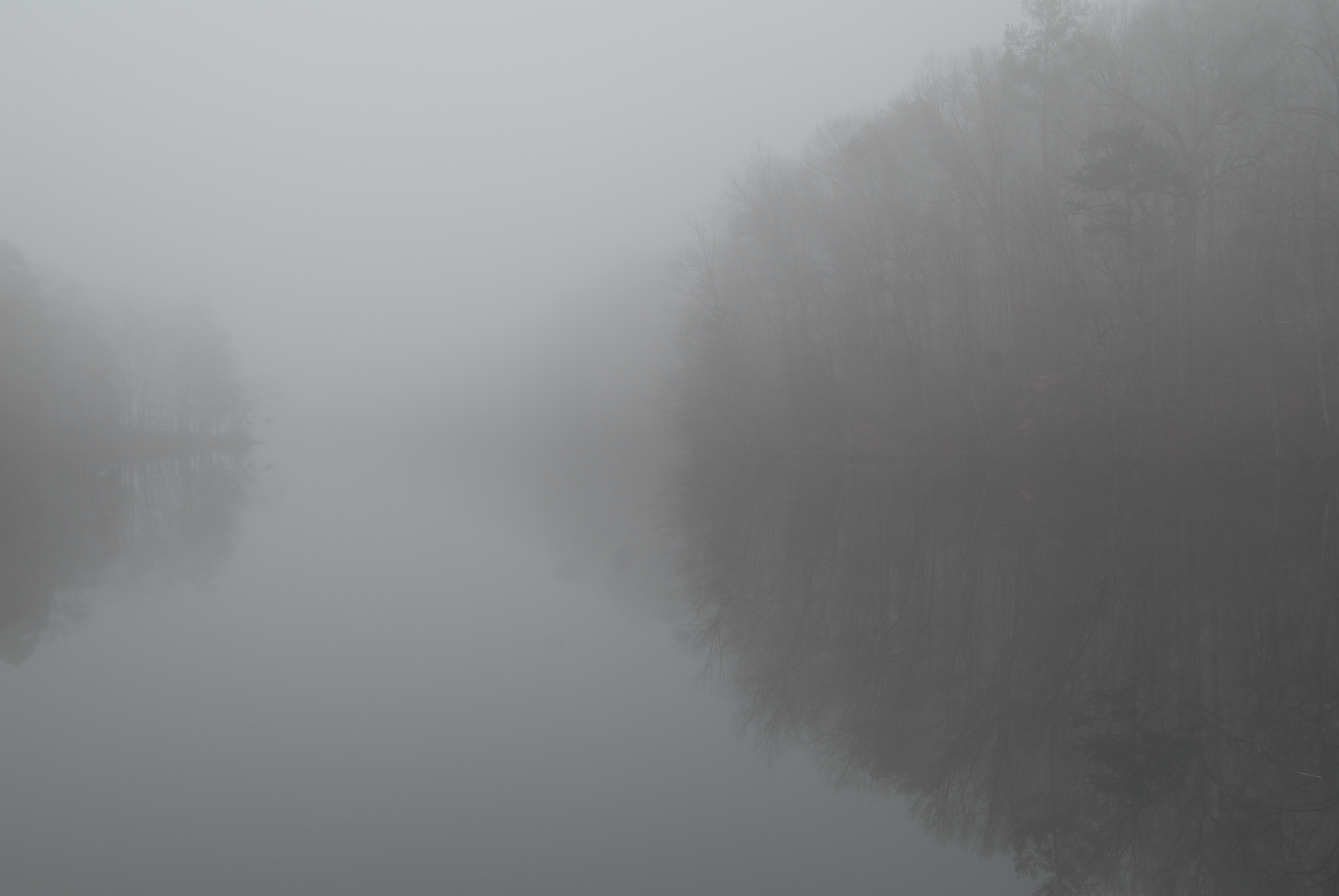
Stone Mountain Lake January 3, 2009 photo by Roy Burke
Stone Mountain Park was Roy’s refuge, relief, workout facility and subject for much of the final 30 years of his life. It was a woodland buffer from the grind of urban life, all the fine particulate matter in the air and the bureaucrats downtown. Those of us who knew him would give anything for another of those walks together through Stone Mountain Park on a breezy day. Post full-time retirement he walked there every day that he could, taking pictures in all seasons and all weather. His second blog Stone Mountain Meanderings is worth your time if you didn’t catch it first time around. This photograph of Stone Mountain Lake at the beginning of 2009 evokes Monet and his water lilies in its painterliness. They were both old men with beards who were familiar with their subject matter, and the brief moments in an average day when nature and weather combine to focus the eye, the hand on the canvas, the camera’s lens.
